Hey there team-
here are my 3 points from the research presentation.
Revitalization- linked to the Granby and Olympia neighborhoods that have
found new life in the mills. How can our design bring a new life to
the area?
the 1786 square plan- this plan is based on a simple grid construction that rotated slightly off true North-
the
Fall Line- this is a geomorphic condition where old rocks of the
continent meet the younger rocks of the coast- interesting in terms of
connection.
p.s.- I am sorry I was late on Wednesday. my apologies to you all
Friday, January 25, 2013
Monday, January 21, 2013


Sunday, January 20, 2013
Saturday, January 19, 2013
Friday, January 18, 2013

Thursday, January 17, 2013
Research Lens Diagram

Analysis

Wednesday, January 16, 2013


Lens Icons

Ai file is on db if anyone wants it or wants to tweak with them, what do y'all think?


New Urbanism; Andrews University
This is a school who incorporates the ideas of New Urbanim into their architecture curriculum with an Urban Studio required for their students. They work as a whole studio on these projects.
They do similar to what we are aiming for: a book, a presentation to the community, etc every year, in different communities.
http://www.andrewsurbandesign.org/projects.html
They do similar to what we are aiming for: a book, a presentation to the community, etc every year, in different communities.
http://www.andrewsurbandesign.org/projects.html
Tuesday, January 15, 2013
Mountain Bandaid
Check out these design competitions! There are three entries that I believe have techniques applicable to our site. In particular the first one called Mountain Band aid because it deals with both grafting and layering while incorporating sustainable design through rainwater collection. All three of these are dealing with sites similar to ours. The graphics are also really nice on the entries!
Mountain Bandaid
Mountain City
Cliff Dwellings
Mountain Bandaid
Mountain City
Cliff Dwellings
New Urbanism
After going through the design guidelines I feel like these are the principles in one way or another that the city is trying to achieve and follow:
PRINCIPLES OF URBANISM
|
The principles of urbanism can be applied increasingly to projects at the
full range of scales from a single building to an entire community.
|
1. Walkability
-Most things within a 10-minute walk of home and work -Pedestrian friendly street design (buildings close to street; porches, windows & doors; tree-lined streets; on street parking; hidden parking lots; garages in rear lane; narrow, slow speed streets) -Pedestrian streets free of cars in special cases |
2. Connectivity
-Interconnected street grid network disperses traffic & eases walking -A hierarchy of narrow streets, boulevards, and alleys -High quality pedestrian network and public realm makes walking pleasurable |
3. Mixed-Use & Diversity
-A mix of shops, offices, apartments, and homes on site. Mixed-use within neighborhoods, within blocks, and within buildings -Diversity of people - of ages, income levels, cultures, and races |
4. Mixed Housing
A range of types, sizes and prices in closer proximity |
5. Quality Architecture & Urban Design
Emphasis on beauty, aesthetics, human comfort, and creating a sense of place; Special placement of civic uses and sites within community. Human scale architecture & beautiful surroundings nourish the human spirit |
6. Traditional Neighborhood
Structure
-Discernable center and edge -Public space at center -Importance of quality public realm; public open space designed as civic art -Contains a range of uses and densities within 10-minute walk -Transect planning: Highest densities at town center; progressively less dense towards the edge. The transect is an analytical system that conceptualizes mutually reinforcing elements, creating a series of specific natural habitats and/or urban lifestyle settings. The Transect integrates environmental methodology for habitat assessment with zoning methodology for community design. The professional boundary between the natural and man-made disappears, enabling environmentalists to assess the design of the human habitat and the urbanists to support the viability of nature. This urban-to-rural transect hierarchy has appropriate building and street types for each area along the continuum. |
7. Increased Density
-More buildings, residences, shops, and services closer together for ease of walking, to enable a more efficient use of services and resources, and to create a more convenient, enjoyable place to live. -New Urbanism design principles are applied at the full range of densities from small towns, to large cities |
8. Green Transportation
-A network of high-quality trains connecting cities, towns, and neighborhoods together -Pedestrian-friendly design that encourages a greater use of bicycles, rollerblades, scooters, and walking as daily transportation |
9. Sustainability
-Minimal environmental impact of development and its operations -Eco-friendly technologies, respect for ecology and value of natural systems -Energy efficiency -Less use of finite fuels -More local production -More walking, less driving |
Taken together these
add up to a high quality of life well worth living, and create places that
enrich, uplift, and inspire the human spirit
We stand for the restoration of existing urban centers and towns within coherent metropolitan regions, the reconfiguration of sprawling suburbs into communities of real neighborhoods and diverse districts, the conservation of natural environments, and the preservation of our built legacy.
We advocate the restructuring of public policy and development practices to support the following principles: neighborhoods should be diverse in use and population; communities should be designed for the pedestrian and transit as well as the car; cities and towns should be shaped by physically defined and universally accessible public spaces and community institutions; urban places should be framed by architecture and landscape design that celebrate local history, climate, ecology, and building practice.
We recognize that physical solutions by themselves will not solve social and economic problems, but neither can economic vitality, community stability, and environmental health be sustained without a coherent and supportive physical framework.
We represent a broad-based citizenry, composed of public and private sector leaders, community activists, and multidisciplinary professionals. We are committed to reestablishing the relationship between the art of building and the making of community, through citizen-based participatory planning and design.
We dedicate ourselves to reclaiming our homes, blocks, streets, parks, neighborhoods, districts, towns, cities, regions, and environment.
Guidelines of City & Campus
USC design guidelines
- build upon distinctive
character via archr and landscape
- stylistically coordinated
- vary street widths and forms
based on hierarchy
- enhances the existing
built and landscape environments while creating new campus "fabric"
and landmark buildings
- wants to reflect use
of campus-research campus in 21st century
- human scale, more than
style, was the most critical factor in a successful campus design
- ‘fabric buildings’
which blend in a frame space rather than make a statement, and ‘landmark’
bldgs., to respond to context, highlighting important intersections
- types of trees
corresponding to certain areas and/or streets
- wants to maintain as
much natural topography as possible
- sustainable design
techniques- particularly water conservation and management
- increase shade,
decrease dark paving and dark roofing
Innovista Master Plan
sustainable urban live/work area
development of a world-class
waterfront park
revitalize critical areas of
downtown and link them to other redevelopment efforts, including the existing
Vista arts and entertainment district
planning area places urban,
mixed-use development within the framework of Columbia’s historic street grid
Innovista district’s
historic grid system will be designed primarily for pedestrians, while others
will provide vehicular service and access to parking
distinguishing feature of
the Innovista Master Plan will be the Congaree Regional Waterfront Park,
celebrating the City’s industrial heritage and riverside location
Mixed-use development at
Innovista will create housing, retail and office space in four- to six-storey
street-fronted buildings with multi-story parking structures
implementing the Master Plan
for the Innovista planning area will permit completion of the Three Rivers
Greenway, providing continuous waterfront access and signifi cant recreational
amenities to the region’s residents
bring urban housing to
downtown Columbia, including the Canal Side residential development along the
Columbia Canal, the City Club project and the Kline Property mixed-use
development along Gervais Street. A Hilton Hotel is under construction adjacent
to the Convention Center and the new USC baseball stadium, which will serve
students, residents and tourists
Redevelopment of the
property along the waterfront for mixed-use real estate and public park use
—and connecting it to downtown—is both a key challenge facing Innovista as well
as a singular opportunity for the community. Downtown Columbia currently has
limited public access to the Congaree
Urban design
Based on a sustainable
“garden city” design concept, the Innovista area will feature landscaped parks,
pedestrian promenades, streets that are friendly to both pedestrians and
bicyclists, and environmentally sustainable buildings.
The architectural design
concept envisions four- to six-story street-fronted urban buildings with parking
in multi-story structures
The urban design plan calls
for distinctive open space and architectural massing considerations to mark
these gateways
The Innovista design concept
creates a distinction between streets designed accessible for cars, but designed
primarily for pedestrians and bicycles (“A” streets), and streets designed for
the automobile (“B” streets) providing efficient vehicular access to all blocks
as well as to their service areas
Open space: The open space
design concept mirrors the historic street grid, transforming existing and
proposed streets into pedestrianfriendly roadways with shade tree canopies,
broad sidewalks and traffic-calming measures. It introduces urban, landscaped
open spaces to the grid along Greene Street and the gateway districts, and
culminates in the Congaree Regional Waterfront Park
The urban
design concept for Greene Street is to create a pedestrian street in the
European tradition as the primary link between the University and the Congaree
Regional Waterfront Park, featuring a narrow right-of-way framed by
street-fronted buildings whose ground floors present active commercial uses to
the street


Layout
Hi Everyone,
I know a few of you have been emailing me because the layout seemed to disappear from the folder but it is back! I am also going to down save it for those of you that have CS5. I think it would be a good idea for all of us to start getting organized so we do not have anymore confusion. In the layout folder we should probably make out own individual folders with our name in order to put our links in. Then each person can save their own InDesign file as Layout_Johnson for example. You can go ahead and use the 3x3 that we talked about in class but I am going to begin to adapt this file so it better utilizes our "Concept Lens Diagram" we talked about in class, so soon you will see me place a "MasterFile" in the layout folder. I am going to keep a master file on my computer as well. As soon as everyone feels comfortable with their layouts I can begin compiling it in the master file and updating it as we move forward.
The other idea I want to bring up is how to diagram these words. I spoke briefly with Mary about this and we think it could be a simple almost "symbol like legend". I am thinking that near the Table of contents there will be a spread that is very graphic maybe with an image of a camera and multiple lenses and from these "lenses" the words would branch off and each word would have its own very simple symbol. Hopefully this image will become self-explanatory to the reader and then can understand we used these concepts as a "filter". Then on the spreads throughout the book near the title of the page these "symbols" will appear. The ones used will be dark and those that aren't can drop in opacity. What do you all think? There are alot of words and this might be the only way of "dumbing it down". I am interested to hear what you all think!!! Any ideas for the symbols it would be really helpful!!!
Thanks everyone!
Monday, January 14, 2013
What does Columbia want?
On bringing in tourism:
"The Columbia
riverfront: Flood the Olympia quarry near the Congaree River to create a
marina. Build shops and restaurants with a South Carolina flair along the lake.
But the real draw would be a one-of-a-kind building on the riverfront to be
designed by the winner of a contest. Think something along the lines of the
silver-ribbon Guggenheim Museum on the riverfront in Bilbao, Spain."
Think Out of the Box:
What will it take to make the Midlands a tourist
magnet?
Perhaps a world-class piece of architecture along
the Congaree River at the Olympia quarry with marinas, stores, restaurants and
condos.
It could be cruises from Columbia to Charleston along
the lakes and rivers leading to the Lowcountry.
When asked whether the riverfront idea might
compete with the city of Columbia's riverwalk plan, MacNulty said: "New
thinking is needed ... to create a 'wow' factor to put the city on the tourism
map."
Columbia Mayor Bob Coble said he appreciated any
idea "that was out of the box," but he wondered whether quarry owners
were ready for development.
Filling with Water:
Watch here two videos on a quarry filling with water due to a flood and I assume a broken levy...
Marina Precedents:
Miami Crazy 'Wow' Factor
World's First Floating Village

-"luxury shipping containers" describe hotel rooms
- apartments, townhouses, offices, hotel, cafe, theater
- car-free community, boat sharing program- encouraging use of water and river

Inspiration
an excerpt from a blogger in Chicago
"
The artificial depths seem ominously
unstable; despite the solid beds of rock that line their walls, it is hard to
behold a quarry without feeling that somehow, Nature will strike back, bring
the walls crumbling down, reclaim the pit, fill the vacuum. Land dikes
separating quarry pits look precarious to begin with, even before they are
pierced by Gothic arch-shaped openings to permit communication between pits.
And water inevitably finds its way in, requiring constant pumping. The thought
of water overwhelming the works of man is, I suspect, a primal fear on some
level. Here it's not just a shadowy thought, but frank reality.
The quarry pit is a window into the
Earth, showing us a slice of what lies buried under our feet. Rock strata that
have not seen daylight in millions of years lay exposed to the world. Tunnels
hint at darker depths still. The invasion of water gives one a visual grasp of
the water table, the rivers moving below the earth's surface.
And finally, the sheer volume of material removed to create these pits beggars imagination."
Precedents
Roman Quarry disposed Opera

Huangshan Mountain Village/ MAD

- low-rise residences echo contours of mountains
- blurs boundaries b/w geometries of nature and architecture
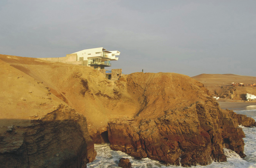
House on the Cliff

(- quarries do the opposite, they ignore natures contours and make their own)
Lefevre House
- integration of landscape and architecture
- bringing elements of surroundings to a tactile level at human scale
Top of Tyrol

- enables onlooker to grasp dimensions of site
- a spiritual place to enjoy the scenery
-"design goal was more the design of a situation in space rather than a building"
- an extension as well as reaction to topography and landscape
- also fun and ridiculous fact- it was all erected via helicopter
see also: Canada; Aurland; and of course Trollstigen
Women at War
- an old bunker turned war museum; honoring past while looking towards future
- interesting entryways and daylighting/skylighting
- turning a bunker into a memorial - "juxtaposition between the protective shell of the bunker and it’s contrasting dangerous subject matter" -quarry felt protective yet dangerous; also, once reclaimed, what is the business that can fuel the needs of the community?
Floating Nature Reserve in England

- nature reserve from abandoned quarry
- floating eco-village form reclaimed materials floating on hollow concrete pontoon
- also visitors center to introduce trails and wildlife around reserve
Stadium in Casablanca in Quarry

- inspired by quarry- designed to resemble mineral
- open-air, but encompassed by blades for sunshade and ventilation
- described as 'oasis' - interesting to turn stark, empty, hot hole into a water-filled, cool, relaxing area
- insular as well as permeable
Jackpot
-but don't get too excited, most are just nature preserves now, and few pictures


1Q=1JKOR
The land area of the quarry is essentially equal to that of the Jacqueline Kennedy Onassis Resevoir in Central Park


image source: centralparknyc.org
history- civil war
Preservation organization
The Chicora page has information on education, preservation, and archaeology.
myth conceptions
This is really interesting to help brush up on the civil war and what was actually taking place politically in South Carolina.
The Chicora page has information on education, preservation, and archaeology.
myth conceptions
This is really interesting to help brush up on the civil war and what was actually taking place politically in South Carolina.
rice
rice
This has some really interesting information regarding rice in the state of SC. This claims that rice was present in the Colony of SC as early as the 1670's. Furthermore, the bibliography has a good list of wonderful sources/books that should at least be looked at to see what has been written.
This has some really interesting information regarding rice in the state of SC. This claims that rice was present in the Colony of SC as early as the 1670's. Furthermore, the bibliography has a good list of wonderful sources/books that should at least be looked at to see what has been written.
Ground water levels
This report shows ground water levels in Richland County between 1949 and 1990. The measurements taken closest to the site (Lincolnshire subdivision north of Columbia) show the groundwater levels are trending towards approximately 230' to 255' above sea level. This could vary across the entire county, but this should be close to the levels of the quarry area.
Sunday, January 13, 2013
Reclamation : Botanical Quarry
Shanghai Botanical Has One Rockin’ Quarry Garden
THUPDI and Tsinghua University recently won the American Society of Landscape Architecture 2012 Honor Award for transforming an abandoned rock quarry in Shanghai into a garden oasis, complete with floating water walkway. After hearing the site had been closed to the public for over a decade, the team spent more than 6 years cleaning, planting, and restructuring the massive space. The final design is a unique multi-layered park that works closely with its quarry roots.
A collection of gardens are sprinkled throughout the upper areas, with plants bursting through rustic walls and fences. A giant metal walkway, which was once a ramp for transporting rocks, descends and curves around the deep water hole, bringing visitors closer to the fresh springs and waterfalls that peacefully flow within breathtaking the space.
http://www.architizer.com/en_us/blog/dyn/49600/shanghai-botanical-has-one-rockin-quarry-garden/#.UPOS2InjnBA


Subscribe to:
Posts (Atom)