A fall line (or fall zone) is the geomorphologic break [1] between an upland region of relatively hard crystalline basement rock and a coastal plain of softer sedimentary rock.[2] A fall line is typically prominent when crossed by a river, for there will often be rapids or waterfalls. Many times a fall line will recede upstream as the river cuts out the uphill dense material, often forming “c”-shaped waterfalls. Because of these features riverboats typically cannot travel any farther inland without portaging, unless locks are built there. On the other hand, the rapid change in elevation of the water, and the resulting energy release, makes the fall line a good location for water mills, grist mills, and sawmills. Because of the need for a river port leading to the ocean, and a ready supply of water power, settlements often develop where rivers cross a fall line.
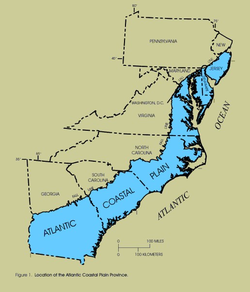
The Atlantic Seaboard Fall Line, or Fall Zone, is a 900-mile (1,400 km) escarpment where the Piedmont and Atlantic Coastal Plain meet in the eastern United States.[4] Much of the Atlantic Seaboard fall line passes through areas where no evidence of faulting is present.
The fall line marks the geologic boundary of hard metamorphosed terrain—the product of the Taconic orogeny—and the sandy, relatively flat outwash plain of the upper continental shelf, formed of unconsolidated Cretaceous and Tertiary sediments. Examples of the Fall Zone include the Potomac River's Great Falls and the rapids in Richmond, Virginia, where the James River falls across a series of rapids down to the tidal estuary of the James River. Columbia, South Carolina is similar as well with the Congaree River.
Before navigation improvements such as locks, the fall line was often the head of navigation on rivers due to rapids and waterfalls, such as the Great Falls of the Potomac River. Numerous cities were founded at the intersection of rivers and the fall line. U.S. Route 1 links many of the fall line cities.
(via usca.edu)
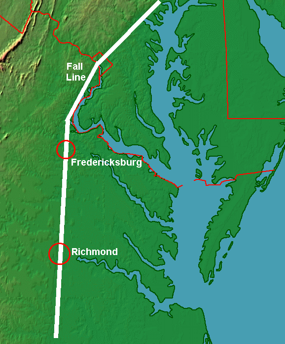
What exactly is the Fall Line you ask? It is the physiographic border between the piedmont and coastal plain regions. The name derives from the river rapids and falls that occur as the water flows from hard rocks of the higher piedmont onto the softer rocks of the coastal plain. On the map below the Fall Line is shown by the white line, with the areas south and east belonging to the Atlantic and Gulf Coastal Plains.


Fall Line
East of I-95, the soil of the Coastal Plain is sandy. It is light-colored (sometimes almost yellow or even white), and flat. There are few hills, though some cliffs have been exposed where rivers have scratched out their valleys.
West of the interstate, the plowed fields of the Piedmont expose red clay and the land rises towards the Blue Ridge. The Interstate 95 highway is a rough guide to the location of the geologic boundary known as the Fall Line, the boundary separating the soft sediments of the Coastal Plain from the hard bedrock of the Piedmont.
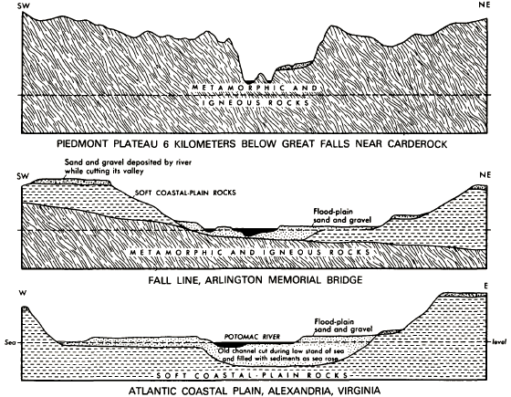
The Piedmont bedrock was once the soft sediments of the Outer Continental Shelf in the Iapetus Ocean, located offshore from the ancient shoreline of Virginia before the Iapetus Ocean closed and the continents collided, plus chunks of continental crust and volcanic island chains in the Iapetus Ocean. When Africa (and Europe) bumped into the North American continent and created the Appalachian Mountains, those crustal fragments and soft sediments were scrunched up from the ocean bottom and pushed onto the North American continent. (You can "scrunch" icing with a fork onto a piece of cake in the same way.)
In the process of being scrunched, the sediments from the Iapetus Ocean floor were squeezed and baked into the hard metamorphic rock that now underlies much of Virginia between I-95 and the Blue Ridge. The former Outer Continental Shelf off the Virginia shoreline in the Iapetus Ocean was transformed and glued to the old continental crust. In addition, as the Iapetus Ocean closed, offshore islands were "docked" against the continental edge and their crust was added (accreted) to the mix. The metamorphosed sediments and crust are exposed clearly now at Great Falls, on the Potomac River just upstream from Washington, DC.
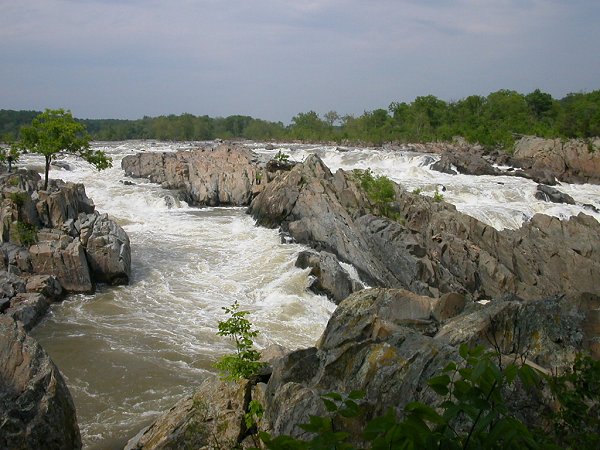
Great Falls, on the Potomac River
After Africa and North America collided and pushed up the Appalachian Mountains, the combined continents then split apart. The crack where they split filled with salty seawater and formed the Atlantic Ocean. When the Atlantic Ocean formed initially, the Virginia shoreline was at the eastern edge of the Piedmont (now roughly the route of I-95).
Over the last 200 million years, sediments have washed down as the mountains eroded. Those sediments have accumulated east of the Piedmont, helping to form the Coastal Plain. Virginia's land area has expanded to the east, as the North American tectonic plate has drifted to the west and the Coastal Plain has widened.
The water levels in the Atlantic Ocean have risen at times. When water rose high enough to cover the eastern edge of Virginia, marine sediments were deposited onto the Coastal Plain. Coastal Plain sediments were deposited by two processes: 1) when ocean levels were higher and 2) as freshwater rivers eroded the modern Appalachian Mountains and carried debris to the edge of the continent.
The sediments on the Coastal Plain, deposited after the continents started to split apart and the Atlantic Ocean formed, have not been baked and squeezed tight. Most sediments located east of the Piedmont are not hardened like the metamorphosed bedrock to the west, and that physical difference is why there is a Fall Line today.
The zone of the "Fall Line"
When today's Virginia rivers flow eastward from the Piedmont onto the Coastal Plain, they leave the Piedmont where the river's bottom is hard rock (with a thin coating of mud deposited since the last flood). When the rivers encounter the easier-to-erode Coastal Plain, the water etches into those soft sediments. The energy of the water carves a deeper channel in the softer sediments, creating waterfalls.
The edge of the Piedmont/Coastal Plain is marked by a line of waterfalls (the Fall Line) where various rivers move from harder to softer bedrock. The waterfalls are most obvious at Great Falls on the Potomac River, on the Rappahannock River at Fredericksburg (look westward from the I-95 bridge), and on the James River near downtown Richmond (look westward from any bridge between I-95 to the Huguenot Bridge). However, the waterfall on the Occoquan River near Lorton has been "dried out" by the construction of a dam, and only a trickle of water flows over the Occoquan Reservoir dam in the summer months. On the rare occasion that Fairfax Water opens its Fall Line property to public visits, you can see the exposed rocks at the Fall Line by walking upstream from the town of Occoquan.
The Fall Line is really a zone rather than just a narrow line. The rapids and waterfalls may extend up to a mile. The zone between the Coastal Plain and the Piedmont physiographic provinces may be drawn even wider, because the actual waterfalls may be far upstream from the geologic boundary between the Piedmont and Coastal Plain bedrock.

migration of Potomac River waterfall from geologic boundary at I-66 bridge upstream to Great Falls
Source: US Geological Survey (USGS) The National Map
For example, the bedrock in the Piedmont is the hard crystalline rock that you can see at Great Falls on the Potomac River. The eastern edge of that hard rock formation is downstream on Teddy Roosevelt Island, at the end of I-66 where it crosses the Potomac River on the Teddy Roosevelt Bridge (connecting Rosslyn with the District of Columbia at the Kennedy Center). Great Falls is 15 miles upstream, showing how the Potomac River has etched its way upstream and carved out Mather Gorge in the crystalline bedrock over the last 2 million years.1

physiographic setting of Great Falls
Source: US Geological Survey (USGS) Bulletin 1471,
The River and the Rocks: The Geologic Story of Great Falls and the Potomac River Gorge
geologic setting of Great Falls
Source: US Geological Survey (USGS) Bulletin 1471,
The River and the Rocks: The Geologic Story of Great Falls and the Potomac River Gorge
References
1. "The Origin Of The Potomac River Valley And The Carving Of Great Falls," The River and the Rocks: The Geologic Story of Great Falls and the Potomac River Gorge, US Geological Survey Bulletin 1471 - Section 4, 1970,http://www.nps.gov/history/history/online_books/grfa/ (last checked september 4, 2011)2. "Game/Sport Fish Regulations," Virginia Department of Game and Inland Fisheries, http://www.dgif.virginia.gov/fishing/regulations/game.asp (last checked August 15, 2012)
Fall Line divides the Coastal Plain and Piedmont physiographic provinces
Source: US Geological Survey Design, Revisions, and Considerations for Continued Use of a Ground-Water-Flow Model of the Coastal Plain Aquifer System in Virginia, Water Resources Investigations Report 98-4085
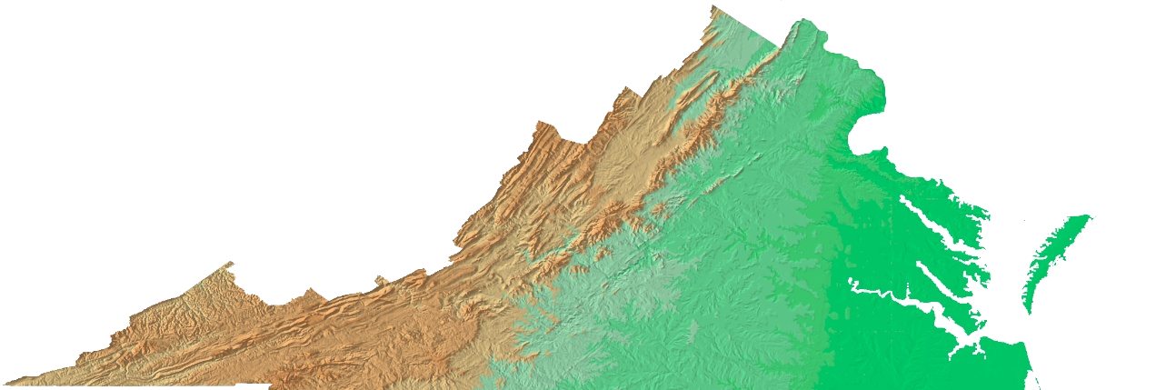
relief map of Virginia
Source: US Geological Survey Open File Report 99-11, Color Shaded Relief Map of the Conterminous United States
The Real First Families of Virginia
River and "Fall Line" Cities
Regions of Virginia - and Why Isn't There An East Virginia?
Virginia Places

Many cities in the eastern United States are located along a geographical feature known as the Fall line. The fall line marks the area where the upland region of the Piedmont meets the Atlantic Coastal Plain. The fall line is typically prominent where a river crosses it, for there will usually be rapids or waterfalls. Since these features frequently mark the head of navigation and supply ample water power, river port settlements and early manufacturing settlements often developed along this line. Many of these settlements are now major American cities. The term fall line is also referenced in the naming of geographical features in the area i.e. Falls lake or Falls of the Neuse
Some examples of Fall Line cities (listed north to south) are
- Philadelphia, Pennsylvania
- Wilmington, Delaware
- Baltimore, Maryland
- Georgetown, Washington, D.C.
- Fredericksburg, Virginia
- Richmond, Virginia
- Petersburg, Virginia
- Roanoke Rapids, North Carolina
- Rocky Mount, North Carolina
- Fayetteville, North Carolina
- Columbia, South Carolina
- Augusta, Georgia
- Macon, Georgia
- Columbus, Georgia
- Montgomery, Alabama
- Tuscaloosa, Alabama
No comments:
Post a Comment